Syllabus- Application of Space Technology in India with references to Education, Agriculture and Industry. Climatic change, Floods, Cyclone, Tsunami, Natural and Manmade Disaster Management.
Number of questions- Mains: 02, Prelims – 10
Mains Questions of the day-
1. What is GIS Technology? Mention role of Geospatial technology in Agriculture.
Introduction:
Write briefly about GIS technology.
Body:
Mention the GIS technology application in agriculture.
Conclusion:
· As a result, geospatial technologies give a farmer with a repository of information that he may utilise to make informed decisions that ensure effective and efficient farm management and enhance productivity.
· To get the most out of their farms, farmers should understand and utilise these technologies in conjunction with their knowledge and expertise.
Content:
· Geospatial technology is a field that is rapidly evolving.
· Geographic information systems (GIS), global positioning systems (GPS), and remote sensing (RS), all new technologies that aid the user in the collecting, analysis, and interpretation of spatial data, are referred to as geospatial technology (GST).
· It is concerned with the relationship, state of artificial and natural objects in space, whether on Earth or elsewhere.
· In India, geospatial technology has made inroads into a variety of areas, both public and private.
· Agriculture, telecommunications, oil and gas, environmental management, forestry, public safety, infrastructure, and logistics are among the major sectors in India that use geospatial technology.
The geospatial industry is expected to grow rapidly in the next few years as stakeholders from all sectors see the value and long-term cost effectiveness of adopting geospatial tools and technologies.
· By 2025, India’s GDP is predicted to reach $9-10 trillion, and the country’s economy would have transformed into one that is highly industrialised and technologically advanced.
· To prepare for the anticipated economic expansion, India would need an effective and modern information and knowledge regime.
· In the future, geospatial technologies will be crucial to information management in India, and uses of this technology can have significant social and national implications.
· The market for GIS-based technology in India has been growing.
· Several Indian states, including Telangana, Andhra Pradesh, Karnataka, Rajasthan, and Tamil Nadu, have begun to use geospatial technology to improve governance and management.
Geospatial Technology’s Impact on Agriculture:
· In the Asia-Pacific area, the use of new and modern information, geospatial, and communication technologies (ICTs) for rural and agricultural development has progressed at a rapid pace during the previous decade.
· Plantation crops are largely surveyed and mapped using geospatial technology.
· In nations like Malaysia and Indonesia, rice mapping is a big endeavor.
· Australia is a prominent consumer of geospatial technologies, with remote sensing and geographic information systems (GIS) being particularly popular for mapping crops like sugarcane and oil palms.
· At the micro-level, geospatial techniques are primarily utilised for mapping groundwater resources, drainage patterns, variable rate fertiliser delivery, and pesticide and insecticide management.
· Increased yields, resource management, prediction of outcomes, and improved farm practises are all benefits of geospatial technologies in agriculture.
Role in Carbon Sequestration:
The act of transferring and securely storing atmospheric CO2 into other long-lived carbon reservoirs is known as carbon sequestration (CS).
· The capacity of integrated RS-GIS to do advanced spatial and/or temporal analysis on several layers of high-resolution data.
· This aids research activities aimed at controlling the global carbon cycle, mostly by giving useful data and assisting with implementation methods.
· In CS administration and monitoring, an integrated RS-GIS can be used as a Decision Support System (DSS) tool.
· The use of an integrated RS-GIS allows for the quantification of climatic and soil conditions across a region’s geographical and temporal variability.
· Carbon stocks have been mapped using remote sensing methods such as Synthetic Aperture Radar (SAR), Light Detection and Ranging (LiDaR), and satellite sensors like as Landsat, SPOT, and Ikonos.
· The recovery of vegetation increases the CS potential of eroded soils.
· C-Lock, a new system that standardises the estimation of agricultural carbon sequestration credits, was developed using a regional-scale GIS as the operating platform.
· The association of soil CS potential with soil erosion type, altitude, soil type, and soil parent material was examined using a GIS in a recent experiment to simulate soil CS potential in eroded locations.
· The regeneration of vegetation boosts the CS potential of degraded soils.
· A biogeochemical model that simulates carbon, nutrient, and water dynamics for various ecosystems, is included in GIS system.
· Precision carbon management, an expanding domain of applied science, is made easier with such a technology.
· In CS management, the synergistic role of RS and GIS technologies was integrated.
· Using an integrated RS-GIS method can help with CS management and monitoring strategies.
· This approach may be used to estimate above- and below-ground biomass, delineate geographic variability, predict potential carbon stocks and revenues, and outline appropriate management strategies for localised and regional scales in climate change mitigation.
· The use of an integrated RS-GIS strategy for precision carbon management will become increasingly obvious in the near future.
· Farmers can better understand their farms’ site-specific demands by using remote sensing, GPS, and GIS.
· They can utilise this information to develop and implement management approaches that assure the best possible utilisation of inputs in order to maximise production and revenues.
2.Mystery ‘space debris found in three areas in Gujarat. Discuss challenges associated to the Space Debris?
Introduction:
Write briefly about Space debris
Body:
Mention the associated challenges and measures to handle space debris.
Conclusion:
· We must think of the space environment as a shared and limited natural resource.
· To continue benefiting from the science, technology and data that operating in space brings, it is vital that we achieve better compliance with existing space debris mitigation guidelines in spacecraft design and operations.
· This is essential for the sustainable use of space.
Content:
space debris:
· Space debris can include natural space debris such as meteoroids, or man-made ones which can include defunct spacecrafts and satellites, stages of rockets which have launched payloads, dead satellites, satellite explosions and collisions.
· According to NASA, “more than 25,000 objects larger than 10 cm are known to exist” as space debris and the estimated population of particles between 1 and 10 cm in diameter is approximately 500,000.
· According to NASA’s estimates, as of January 2022, the amount of material orbiting the Earth exceeded 9,000 metric tons.
Associated challenges with the space debris:
· Since the beginning of the space age in 1957, tonnes of rockets, spacecraft and instruments have been launched to space.
· Initially, there was no plan for what to do with them at the end of their lives.
· Since then, numbers have continued to increase and explosions and collisions in space have created hundreds of thousands of dangerous debris.
· The biggest contributor to the current space debris problem is explosions in orbit, caused by left-over energy – fuel and batteries – onboard spacecraft and rockets.
· Despite measures being in place for years to prevent this, we see no decline in the number of such events.
· Trends towards end-of-mission disposal are improving, but at a slow pace.
Measures need to handle the Space Debris:
· In view of the constant increase in space-traffic, we need to develop and provide technologies to make debris prevention measures, and European Space Agency is doing just that through its Space Safety Programme.
· In parallel, regulators need to monitor the status of space systems as well as global adherence to debris mitigation under their jurisdiction more closely.
· International guidelines and standards now exist making it clear how we can reach a sustainable use of space:
Ø Design rockets and spacecraft to minimise the amount of ‘shedding’ material becoming detached during launch and operation, due to the harsh conditions of space.
Ø Prevent explosions by releasing stored energy.
Ø ‘passivating’ spacecraft once at the end of their lives
Ø Move defunct missions out the way of working satellites
o either by de-orbiting them or
o moving them to a ‘graveyard orbit’
Ø Prevent in-space crashes through careful choice of orbits and by performing ‘collision avoidance manoeuvres’.
· Many space agencies, private companies and other space actors are changing their behaviour to adhere to these guidelines but this is not enough
· The number of debris objects, their combined mass, and the total area they take up has been steadily increasing since the beginning of the space age.
· This is further fueled by a large number of in-orbit break-ups of spacecraft and rocket stages.
· The total area that space debris takes up is important as it is directly related to how many collisions we expect in the future.
· As things stand, collisions between debris and working satellites is predicted to overtake explosions as the dominant source of debris.
· On average over the last two decades, 12 accidentals fragmentations have occurred in space every year and this trend is unfortunately increasing.
· Fragmentation events describe moments in which debris is created due to collisions, explosions, electrical problems and even just the detachment of objects due to the harsh conditions in space.
· While not all satellites currently comply with international guidelines, more and more space actors are attempting to stick to the rules.
· Rocket bodies are among the largest objects we send to space and are at a high risk of being involved in catastrophic collisions.
· All steps to ensure they do not linger in orbit after a maximum of 24 hours from launch.
· High rates of debris mitigation in geostationary orbit
· Satellites launched into the geostationary protected region, 35 586 – 35 986 km in altitude, have very high rates of adherence to debris mitigation measures.
· Between 85% and 100% that reached the end of their life this decade attempted to comply with these measures, of which 60 – 90% did so successfully.
· In geostationary orbit, there is a clear commercial interest for operators to keep their paths free from defunct satellites and debris – to not do so would put their spacecraft, and bottom line, at serious risk.
· Continued creation of space debris will lead to the Kessler syndrome, when the density of objects in low Earth orbit is high enough that collisions between objects and debris create a cascade effect, each crash generating debris that then increases the likelihood of further collisions.
· At this point, certain orbits around Earth will become entirely inhospitable.
Prelims Questions of the day:
1.Which of the following statement is correct regarding the New Space India Limited?
A. It works under Department of Science and Technology
B. It is a public sector undertaking to handle ISRO’s commercial deals with foreign customers.
C. It will deal with capacity building of local industry for space manufacturing.
D. It was established in 2020.
Answer: C
Explanation:
New Space India Limited
· To commercially exploit the research and development work of the Indian Space Research Organisation (ISRO). NSIL was established in 2019. It is a completely Government owned Undertaking / CPSE. It is under the administrative control of the Department of Space (DOS).
· One of the mandates of NSIL is to mass-produce and manufacture the SSLV and the more powerful PSLV in partnership with the private sector in India through technology transfers.
· Its aim is to use research and development carried out by ISRO over the years for commercial purposes through Indian industry partners.
· It differs from ISRO’s existing commercial arm Antrix Corporation:
Ø Antrix will handle ISRO’s commercial deals for satellites and launch vehicles with foreign customers.
Ø NSIL will deal with capacity building of local industry for space manufacturing.
2.Which of the following is correct regarding the Chandrayaan-3?
A. It is aiming to achieve a soft landing on the North pole of lunar Surface
B. It will not carry an orbiter
C. It will not carry a lander and a rover
D. It proposed in partnership with Russia.
Answer: B
Explanation:
Chandrayaan-3:
· The space agency is aiming to achieve a soft landing on the south pole of the lunar surface, which is the least explored region of the Moon to date.
· Unlike its predecessor (Chandrayaan-2), Chandrayaan 3 will not carry an orbiter but will include a lander and a rover to study the lunar surface
· The subsequent failure of the Vikram lander in chandrayaan-2 led to the pursuit of another mission to demonstrate the landing capabilities needed for the Lunar Polar Exploration Mission proposed in partnership with Japan for 2024.
3.Which of the following mission of ISRO with NASA for studying hazards and global environmental change?
A. NISAR mission
B. IRNSS-NAVIC
C. GAGAN
D. IRS-IA
Answer: A
Explanation:
· NASA-ISRO Synthetic Aperture Radar (NISAR) mission: It is optimised for studying hazards and global environmental change and can help manage natural resources better. It will provide information to scientists to better understand the effects and pace of climate change.
· Navigation services are necessary to meet the emerging demands of the Civil Aviation requirements and to meet the user requirements of the positioning, navigation and timing based on the independent satellite navigation system.
· ISRO worked jointly with Airport Authority of India (AAI) in establishing the GPS Aided Geo Augmented Navigation (GAGAN) system to meet the Civil Aviation requirements.
· Similarly, it established a regional satellite navigation system called the Indian Regional Navigation Satellite System (IRNSS-NAVIC) to meet the user requirements of the positioning, navigation and timing services.
· The Indian Remote Sensing Satellite-1A or the IRS-1A was launched on March 17th, 1988 from a Soviet cosmodrome, the Baikonur Cosmodrome currently in Kazakhstan. The satellite was the first Indian-made remote sensing satellite developed by the Indian Space Research Organisation (ISRO). The launch vehicle was a Russian Vostok. It was launched into a sun-synchronous polar orbit.
4.Shukrayaan-1 mission is planned to orbiter for which of the following celestial bodies?
A. Mars
B. Moon
C. Jupiter
D. Venus
Answer: D
Explanation:
Shukrayaan-1:
· It is a proposed orbiter to Venus.
· Shukrayaan-1 is a planned orbiter to Venus by the Indian Space Research Organisation to study the surface and atmosphere of Venus.
· Although 2024 has been doing the rounds as the likely year for the ISRO’s Venus mission, the space agency can announce a schedule only after the Indian government gives the go-ahead for the mission.
· Venus offers different challenges compared to Mars, given the thick atmosphere and surface activity, which make it a complex planet.
5.Which of the following fuel is/are used as propellants in Cryogenic engine?
A. Liquid hydrogen
B. Liquid oxygen
C. Both A and B
D. None
Answer: C
Explanation:
GISAT-1:
· ISRO’s Geo-Imaging Satellite GISAT-1 launch failed recently.
· Launch was supposed to place EOS-03, an earth observation satellite, into a geosynchronous Transfer Orbit (GTO) ultimately reaching Geostationary Orbit (GEO) via GSLV-F10 rocket.
· Mission failed due to the Cryogenic Upper Stage (3rd Stage of GSLV) ignition did not happen due to technical anomaly.
· Cryogenic stage is the last stage of space launch vehicles which makes use of Liquid Oxygen (LOX) and Liquid Hydrogen (LH2) as propellants.
· Geosynchronous Satellite Launch Vehicle (GSLV) is a 3-stage expendable space launch vehicle designed, developed, and operated by ISRO to launch satellites and other space objects into GTO
6.Which of the following is/are true regarding the Space Debris?
A. Space debris consists of both natural (meteoroid) and artificial (man-made) particles.
B. Meteoroids are in orbit about the Earth
C. Most artificial debris is in orbit about the sun which is commonly referred to as orbital debris.
D. It is found in Medium Earth orbit (MEO).
Answer: A
Explanation:
· China rocket debris fell in Indian Ocean near Maldives.
· Parts of Long March 5B re-entered the atmosphere and landed in the Indian Ocean, with the bulk of its components destroyed upon re-entry into the Earth’s atmosphere.
· Long March 5B was carrying components for the construction of China’s space station, which will be completed by the end of next year.
· Last year, debris from another Chinese Long March rocket fell on Ivory Coast, damaging several buildings.
Space Debris:
· Space debris encompasses both natural (meteoroid) and artificial (man-made) particles.
· Meteoroids are in orbit about the sun, while most artificial debris is in orbit about the Earth which is commonly referred to as orbital debris.
· Orbital debris is any man-made object in orbit about the Earth which no longer serves a useful function. Such debris includes non-functional spacecraft, abandoned launch vehicle stages, mission-related debris and fragmentation debris.
· Much of the debris is in low Earth orbit (LEO), though some debris can be found in geostationary orbit.
7.Which of the following project of the ISRO related to the Space debris?
A. NISAR
B. NETRA
C. RESPOND
D. YUVIKA
Answer: B
Explanation:
· There are about 500,000 pieces of space debris the size of a marble or larger orbiting the Earth, travelling at speeds up to 17,500 mph.
· International guidelines suggest removing space crafts from LEO within 25 years of the end of their mission. However, only 60 percent of missions follow the guidelines.
· Strategies to Tackle Space Debris: Space debris is tracked by a number of countries, including Germany, France, UK and USA. ISRO has come up with ‘Project NETRA’ – an early warning system in space to detect debris and other hazards to Indian satellites. Indraprastha Institute of Information Technology Delhi is working on a project titled “Orbit computation of Resident Space Objects for Space Situational Awareness” to predict collision from space debris.
· Indian Space Research Organisation has launched a special programme for school children called ‘Young Scientist Programme’ (YSP) or ‘Yuva Vigyani Karyakram’ (YUVIKA) which is primarily aimed at imparting basic knowledge on space technology, space science and space applications to the younger ones. The programme will include talks, experience sharing by the eminent scientists, facility and lab visits, exclusive sessions for discussions with experts, practical and feedback sessions.
· ISRO started the RESPOND (Research Sponsored) programme in the 1970s, with the objective of encouraging academia to participate and contribute to various Space-related research activities. Under RESPOND, projects are taken up by Universities/Academic Institutions in the areas of relevance to the Space Programme.
8.Which of the following is correct regarding the Indian Space Association?
A. It is a public sector undertaking
B. It will enable the opening up of the space sector to start-ups and the private sector
C. The industry association will act under the Ministry of Commerce and Industry
D. It consists of various stakeholders from ISRO only
Answer: B
Explanation:
· The Prime Minister recently launched the Indian Space Association (ISpA), an industry body consisting of various stakeholders of the Indian space domain.
· ISpA:
· The industry association will act as an independent and a “singlewindow” agency for enabling the opening up of the space sector to start-ups and the private sector.
· ISpA will also work towards building global linkages for the Indian space industry to bring in critical technology and investments into the country to create more high-skill jobs.
Status of India’s Space industry:
· The current global space economy is estimated at US$ 360 billion, with India accounting for ~2% (US$ 7 billion).
· In the global space market, rocket and satellite launch services, an area in which ISRO specialises, amount to only 5% share.
· Satellite-based services and ground-based systems account for the remaining 95%.
· Several private companies are developing plans to take paying customers to space on a regular basis leading to a rapid growth in space tourism industry.
9.Which of the following represents an altitude of 100 km (62 miles) above the surface of the earth where atmospheric lift no longer supports a flying object and the object would need to reach orbital velocity or risk falling back to Earth?
A. Karman line
B. Kuiper belt
C. Kepler-62e
D. Asteroid belt
Answer: A
Explanation:
· According to the Fédération Aéronautique Internationale (world governing body for aeronautic and astronautic records), space starts at an altitude of 100 km (62 miles) above the surface of the earth. This is the Karman line where atmospheric lift no longer supports a flying object and the object would need to reach orbital velocity or risk falling back to Earth.
· Space travel is referred to as any flight operation that takes one or more passengers beyond the altitude of 100 km and thus into space.
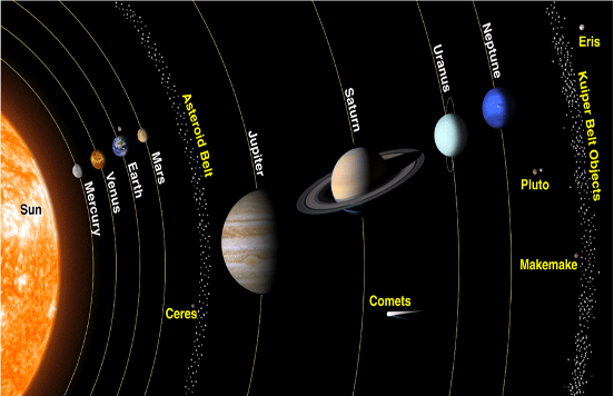
· The Kuiper belt is a circumstellar disc in the outer Solar System, extending from the orbit of Neptune at 30 astronomical units (AU) to approximately 50 AU from the Sun. It is similar to the asteroid belt, but is far larger—20 times as wide and 20–200 times as massive
· Kepler-62e is a super-Earth exoplanet (extrasolar planet) discovered orbiting within the habitable zone of Kepler-62
· The asteroid belt is a torus-shaped region in the Solar System, located roughly between the orbits of the planets Jupiter and Mars. It contains a great many solid, irregularly shaped bodies, of many sizes, but much smaller than planets, called asteroids or minor planets.
10.Which of the following theories represents the application of Einstein’s theory of general relativity?
A. Gravitational waves
B. Black hole
C. Both A and B
D. None
Answer: C
Explanation:
· General relativity is a theory of gravitation developed by Albert Einstein between 1907 and 1915.
· The theory of general relativity says that the observed gravitational effect between masses results from their warping of spacetime.
· Gravitational waves are ‘ripples’ in space-time caused by some of the most violent and energetic processes in the Universe.
· Albert Einstein predicted the existence of gravitational waves in 1916 in his general theory of relativity.
· Einstein’s mathematics showed that massive accelerating objects (such as neutron stars or black holes orbiting each other) would disrupt space-time in such a way that ‘waves’ of undulating space-time would propagate in all directions away from the source.
· These cosmic ripples would travel at the speed of light, carrying with them information about their origins, as well as clues to the nature of gravity itself.
· The strongest gravitational waves are produced by cataclysmic events such as colliding black holes, supernovae (massive stars exploding at the end of their lifetimes), and colliding neutron stars.
· Other waves are predicted to be caused by the rotation of neutron stars that are not perfect spheres, and possibly even the remnants of gravitational radiation created by the Big Bang.
· A black hole is a place in space where gravity pulls so much that even light cannot get out.
· The gravity is so strong because matter has been squeezed into a tiny space.
· This can happen when a big star is dying (our sun will never turn into a black hole as it is not big enough to make a black hole).
· Because no light can get out, so they are invisible.