
Syllabus- India – Climate- Mechanism of Monsoon, effect of El-Nino and La Nino, Rainfall variability- Floods and Drought.
Number of questions- Mains: 02, Prelims – 10
Mains Questions of the day-
1. Explain the factors responsible for the origin of ocean currents and mention its Characteristics.
Introduction: –
Write briefly about ocean currents.
Body: –
Mention the factors responsible for origin of Ocean Currents.
Explain its characteristics.
Conclusion: –
Ocean currents influence the regional climate, navigation and fishing.
Content: –
Ocean currents: –
Ocean currents are streams made up of horizontal and vertical components of the circulation system of ocean waters.
The following are the factors responsible for origin of ocean currents:
- Planetary winds:
Planetary winds are the principal cause of the origin of ocean currents.
Wind blowing on the surface of the ocean pushes the water to move. Friction between the wind and the water surface affects the movement of the water body in its course.
- Difference of density and salinity:
Difference of density and salinity in ocean water motivates denser waters to sink and move as undercurrents; whereas lighter waters move towards the denser water as surface currents.
- The rotation of the Earth:
The rotation of the Earth causes Coriolis force which affects the direction of movement of water and leads to formation of ocean currents.
- The shape of coastline:
The shape of coastline is also an important factor that affects the current in the oceans.
- Gravity:
Gravity tends to pull the water down and create gradient variation.
- Temperature of water:
Cold-water ocean currents occur when the cold water at the poles sinks and slowly moves towards the equator.
Warm-water currents travel out from the equator along the surface, flowing towards the poles to replace the sinking cold water.
The following are the characteristics of ocean currents: –
- Major ocean currents are greatly influenced by the stresses exerted by the prevailing winds and coriolis force.
- The oceanic circulation pattern roughly corresponds to the earth’s atmospheric circulation pattern.
- At higher latitudes, where the wind flow is mostly cyclonic, the oceanic circulation follows this pattern.
- In regions of pronounced monsoonal flow, the monsoon winds influence the current movements.
- Due to the coriolis force, the warm currents from low latitudes tend to move to the right in the northern hemisphere and to their left in the southern hemisphere.
- The oceanic circulation transports heat from one latitude belt to another in a manner similar to the heat transported by the general circulation of the atmosphere.
- The cold waters of the Arctic and Antarctic circles move towards warmer water in tropical and equatorial regions, while the warm waters of the lower latitudes move polewards.
- On regional climate:
- Winds blowing over a warm current become warm and at the same time, pick up moisture.
- Thus, the wind that reaches the land brings down the temperature and causes heavy rainfall.
- Ocean currents also lower the temperature of a region which makes the region much cooler than other places.
- Navigation:
- By using, real-time and short-term forecasted currents, ships can be safely docked and undocked and safely navigated through coastal waters.
- Lack of this knowledge can lead to collisions and delayed arrivals.
- Ships sailing with a current gain speed which helps in saving fuel and time.
- Ships moving against a current lose speed.
- Fishing:
- Places where cold and warm currents meet are ideal for the growth of plankton which is food for fish.
- These regions thus have developed into major fishing grounds of the world.
2a. What are Tropical Cyclones and mention the favorable condition for cyclone?
2b. Explain why are more cyclones generated in the Bay of Bengal with more severe than the one generated over the Arabian Sea?
2c. Explain the India’s cyclone management framework?
Introduction: –
Write about Tropical cyclones
Body: –
- Mention the favorable conditions for Tropical cyclones.
- Mention reasons why there are more Cyclone in Bay of Bengal branch with more severe than one that compare to Arabian sea branch Cyclone.
- Write briefly about India’s Cyclone Management Framework.
Conclusion: –
- Establishing a state-of-the-art cyclone Early Warning System (EWS) involving observations, predictions, warnings and customized local-scale advice for decision makers for managing the impact of cyclones.
- Additionally, an Aircraft Probing of Cyclone Facility can be created for India to effectively fill the critical observational data gaps.
- Infrastructural measures like ensuring safety of critical infrastructure, development of multi-purpose cyclone shelters, all weather road links etc.
- Idea of Public-Private Partnership can be explored to mobilize the finances.
- Steps in coastal areas including mapping and delineation of the coastal wetlands, mangrove areas etc. and adopting an eco-sensitive approach to development in the area. The coastal area defenses like mangroves, shelterbelts act as natural defenses.
- Developing an integrated hazard mitigation framework taking into account cyclone and associated storm surge, wind hazard, rainfall run-off etc.
- Establishing a comprehensive Cyclone Disaster Management Information System (CDMIS) covering all phases of Disaster Management.
Content: –
2a.Tropical Cyclone: –
- Tropical cyclones are intense water-rotating systems formed by strong winds around low-pressure areas.
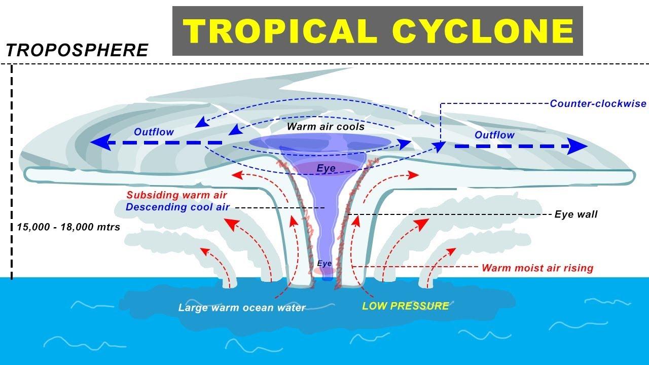
- They are also called typhoons or hurricanes.
- The Indian subcontinent experiences cyclones from two basins:
- The Bay of Bengal basin and
- The Arabian Sea basin.
- April-May and October-December periods are conducive for cyclones.
Conditions favorable for Tropical Cyclone:
- Large sea surface with temperature higher than 27° C;
- Presence of the Coriolis force;
- Small variations in the vertical wind speed;
- A pre-existing weak low-pressure area or low-level-cyclonic circulation;
- Upper divergence above the sea level system
2b. The Indian subcontinent experiences cyclones from two basins:
- The Bay of Bengal basin and
- The Arabian Sea basin.
The following are the reasons for one of the two, more cyclones are generated in the Bay of Bengal and cyclones here have also been more severe than the one generated over the Arabian Sea:
- The Bay of Bengal:
- receives higher rainfall and
- constant inflow of fresh water from the Ganga and Brahmaputra rivers.
This means that the Bay’s surface water keeps getting refreshed, making it impossible for the warm water to mix with the cooler water below, making it ideal for a depression.
- On the other hand, the Arabian Sea:
- receives stronger winds that help dissipate the heat, and
- the lack of constant fresh water supply helps the warm water mix with the cool water, reducing the temperature.
2c. India’s cyclone management framework: –
National Cyclone Risk Management Project works as the holistic strategy by clubbing all of India’s disaster management efforts under four components as:
- Component A:
Improvement of early warning dissemination systems through improved cyclone forecasting, involving IMD and ISRO.
- Component B: Cyclone risk mitigation investment through:
- Building cyclone shelters and infrastructure based on ISO standards.
- Holistic coastal management and conservation of coastal wetlands through Coastal Regulation Zones (CRZ), Integrated Coastal Zone Management (ICZM) and protection of bio-shields like Mangroves.
- Building a community-based Disaster management system.
- Component C:
- Technical assistance for hazard risk management
- capacity building through Vulnerability Analysis
- Risk Assessment and
- community capacity building.
- Component D:
Project management and institutional support through National, State and District level institutional mechanism and coordination.
Prelims Questions of the day: –
1. Which of the following statements best describes Geostrophic winds?
- It is the wind that blows parallel to the isobars when the Coriolis force is balanced by the pressure gradient force.
- It is a severe snowstorm characterized by strong sustained winds.
- it is a downslope wind flowing from high elevations of mountains, plateaus, and hills down their slopes to the valleys or plains below.
- None of the above
Answer: A
Explanation: –
- The rate of change of pressure with respect to distance is the pressure gradient. The pressure gradient results in a net force that is directed from high to low pressure and this force is called the pressure gradient force.
- Coriolis force is an apparent force that arises because of the earth’s spin around its axis. It deflects the wind to the right direction in the northern hemisphere and to the left in the southern hemisphere. The Coriolis force acts perpendicular to the direction of motion and increases with increasing wind velocity i.e., the more the velocity, more is the wind deflection.
- Geostrophic wind is the wind that blows parallel to the isobars when the Coriolis force is balanced by the pressure gradient force. Since the Coriolis force is zero at the equator there are no geostrophic winds at the equator.
2. Consider the following statements with respect to Inter-Tropical Convergence Zone (ITCZ) which of the following statement is incorrect:
- ITCZ is a low-pressure zone that moves with the apparent movement of the sun.
- Tropical Cyclone’s paths over India are mainly determined by the position of ITCZ.
- it is a zone where air tends to descend.
- In July, the ITCZ is located around 20°N-25°N latitudes (over the Gangetic plain), sometimes called the monsoon trough.
Answer: C
Explanation: –
- The Inter-Tropical Convergence Zone (ITCZ) is a low-pressure zone located at the equator where trade winds converge, and so, it is a zone where air tends to ascend. This convergence zone lies more or less parallel to the equator but moves north or south with the apparent movement of the sun.
- In July, the ITCZ is located around 20°N-25°N latitudes (over the Gangetic plain), sometimes called the monsoon trough. This monsoon trough encourages the development of thermal low over north and northwest India. Due to the shift of ITCZ, the trade winds of the southern hemisphere cross the equator between 40° and 60°E longitudes and start blowing from southwest to northeast due to the Coriolis force. It becomes southwest monsoon. In winter, the ITCZ moves southward, and so the reversal of winds from northeast to south and southwest takes place. They are called northeast monsoons.
- The frequency of the tropical depressions originating from the Bay of Bengal varies from year to year. Their paths over India are mainly determined by the position of ITCZ which is generally termed as the monsoon trough. As the axis of the monsoon trough oscillates, there are fluctuations in the track and direction of these depressions, and the intensity and the amount of rainfall vary from year to year.
3. Which of the following type of rainfall is not associated with India?
- Orography
- Convection
- Cyclones
- Anticyclones
Answer: D
Explanation:
Rainfall in India is not associated with anticyclones. An ‘anticyclone’ is opposite to a cyclone, in which winds move into a low-pressure area. In an anticyclone, winds move out from a high-pressure area with wind direction clockwise in the northern hemisphere, anti-clockwise in the southern hemisphere.
4.Most of the India’s rainfall is associated with which of the following?
- Cyclonic
- Convectional
- Elusive
- Orographic
Answer: B
Explanation:
Most of India’s rainfall is convectional. The convectional rainfall is prevalent in equatorial regions. In these, the warm air rises up and expands then, reaches at a cooler layer and saturates, then condenses mainly in the form of cumulus or cumulonimbus clouds. In the equatorial regions, the precipitation due to convectional rainfall occurs in the afternoon.
5. Which of the following statement is incorrect with respect to Western Disturbances?
- They are the extratropical storm.
- They are driven into India by the westerly jet stream.
- They bring rainfall in Northern India during the winter season.
- When the Western Disturbances approach a region, a decline in the night temperatures is observed.
Answer: D
Explanation:
- A western disturbance is an extratropical storm originating in the Mediterranean region that brings sudden winter rain to the northern parts of the Indian subcontinent. The moisture in Western Disturbances usually originates over the Mediterranean Sea, the Caspian Sea, and the Black Sea
- An increase in the prevailing night temperature generally indicates an advance in the arrival of the western cyclonic disturbances.
- The upper air circulation in the Northern Indian region is dominated by a westerly flow. An important component of this flow is the jet stream. These jet streams are located approximately over 27°-30° north latitude, therefore, they are known as subtropical westerly jet streams.
- Over India, these jet streams blow south of the Himalayas, all through the year except in summer. The western cyclonic disturbances experienced in the north and north-western parts of the country are brought in by this westerly flow.
- Western Disturbances are important to the development of the Rabi crop in the northern subcontinent, which includes the locally important staple wheat.
6. The place in India receiving the lowest rainfall is?
A. Leh
B. Jaisalmer
C. Bikaner
D. Jodhpur
Answer: A
Explanation:
The place in India receiving the lowest rainfall is Leh. The average annual precipitation in these regions is less than 50 cms. The cities like Jaisalmer in Rajasthan and Leh in Ladakh receives the least rainfall.
7.Which of the following receives rainfall by north-eastern monsoon?
- Tamil Nadu
- Assam
- Kerala
- West Bengal
Answer: A
Explanation:
Tamil Nadu which lies on Coromandel coast receives rainfall during the winter season specially in months of October and November. This happens because it falls in the way retreating of north-east monsoonal winds.
8.Where are the Rain forests found?
- Central India
- Eastern Ghats
- North-Eastern Himalayas and Western Ghats
- North-Western Himalayas and Eastern Ghats
Answer: C
Explanation:
North eastern Himalayas and western Ghats are the regions in India having rainfall greater than 200 cm. Due to high temperature and high precipitation Rainforests exist in these places.
9.Winter rains in North and North-West India are generally associated with the which of the following phenomenon?
- Retreating monsoon
- Temperate cyclones
- Local thunderstorms
- Shift in jet stream movement
Answer: B
Explanation:
Winter rains in North and North-West India are generally associated with the phenomenon of Temperate cyclones. In the winter season temperature cyclone occurred in Arabian sea. This phenomenon led a rain in the North-West India.
10. The western disturbances which cause winter rain in India originates in which of the following areas?
- Pakistan
- Bay of Bengal
- West Asia
- Himalayas
Answer: C
Explanation:
The western disturbances which cause winter rain in India originate in West Asia. An approaching western disturbance, however, is expected to cause a change of weather in northern and central India and western parts of Maharashtra. A WD is associated with rainfall, snowfall and fog in northern India. Upon its arrival in Pakistan and northern India, clouds along with rain and snow also arrive.